Travel Alaska's Arctic Region | Welcome to the Land of the Midnight Sun

Thousands of caribou migrate through the Brooks Range area each year. They travel through millions of acres of wilderness park lands in the Cape Krusenstern National Monument, Kobuk Valley National Park, Noatak National Preserve, Selawik National Wildlife Refuge, Gates of the Arctic National Park and Preserve and the Arctic National Wildlife Refuge. Backpacking in these isolated mountains or floating down the unspoiled rivers are unparalleled wilderness experiences.Gates of the Arctic National Park and Preserve, one of the finest wilderness areas in the world, straddles the Arctic Divide in the Brooks Range, America's northernmost chain of mountains. Second only to Wrangell-St. Elias National Park in size, Gates of the Arctic covers 13,238 square miles, sprawls 800 miles from east to west and is entirely north of the Arctic Circle. It extends from the southern foothills of the Brooks Range, across the range's ragged peaks and down onto the North Slope. Most of the park is a maze of glaciated valleys and gaunt, rugged mountains covered with boreal forest or treeless slopes of Arctic tundra north of the divide. It is a habitat for grizzly bears, wolves, Dall sheep, moose, caribou and wolverines. Fishing is considered superb for grayling and Arctic char in the clear streams and for lake trout in the larger, deeper lakes. Within this preserve are six Wild and Scenic Rivers, miles of valleys and tundra slopes to hike and, of course, the Gates themselves. Mt Boreal and Frigid Crags are the gates that flank the north fork of the Koyukuk River. In 1929 Robert Marshall found an unobstructed path northward to the Arctic coast of Alaska through these landmark mountains.
 |
NAT01: Barrow | Midnight Sun Tours on Top of the World ► from Anchorage | Fairbanks |
|
|
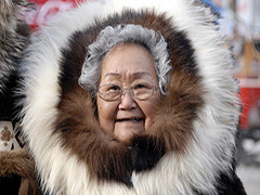
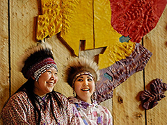
Barrow is situated 1,300 miles south of the North Pole, making it the northernmost community in the United States. Two-thirds of its approximately 4,500 residents are of Inupiat Eskimo descent. The local culture is an interesting mix of traditional lifestyles influenced by community investments from the profits of the Alaskan Pipeline. Visitors to Barrow can learn more about Inupiat culture and history at the Inupiat Heritage Center, or by visiting during the Nalukataq - the traditional spring whaling festival, usually held in June. |
||
 |
NAT02: Kotzebue | Arctic Circle Inupiat Eskimo Heritage Tours ► from Anchorage |
|
|
Kotzebue, with a population of about 3000, is the largest Eskimo community above the North American Arctic Circle. Though incorporated as a city, Kotzebue is essentially still a village, and offers a wide variety of interesting experiences to visitors. The village is situated on the northern tip of the Baldwin Peninsula, 26 miles above the Arctic Circle, 1479 miles south of the North Pole and 175-miles from the Siberian mainland. For hundreds of years Kotzebue, or Qikiqtagruk as it is called in Inupiaq, the Eskimo language of the area, has been the trading and gathering center for the entire area. |
||
 |
NAT03: Brooks Range & Gates of the Arctic National Park Flightseeing Tour ► from Fairbanks |
|
|
Fly north from Fairbanks and wonder at the story of the vast and remote land below ... the traditional peoples that continue to sustain their lifestyles and cultures in the expansive Yuon River valley as they have for thousands of years ... the gold mining activity that continues nearly 100 years after the yello metal first brought newcomers rushing north ... the Trans Alaska Pipeline symbolizing the immense changes brought to Alaska's Arctic by the discovery of oil just over 30 years ago. Experience the rugged and magnificent Brooks Mountain Range. The flight route takes you inside the Gates of the Arctic National Park, the wild and pristine jewel of the national park system. Learn about the faszinating story of the Brooks Range, it's people and history. |
||
 |
NAT04: The Dalton Highway: Alaska above the Arctic Circle Fly-Drive Tour ► from Fairbanks |
|
|
The Dalton Highway slices through northern Alaska from Livengood to the oil fields of Prudhoe Bay. Built in 1974 as the service road for the Trans-Alaska Pipeline, the highway is not to be taken lightly. It's a mostly gravel thoroughfare often ruled by 18-wheelers. Services are few, and signs warn of everything from steep grades to avalanches. However, the signs say little of the road's chief attribute: some of North America's most dramatic scenery. The 414-mile road from Livengood to Prudhoe Bay, Alaska, carves a path through forest and tundra, crosses the Yukon River and traverses the magnificent Brooks Range. |
||
 |
NAT06: Bettles Lodge | Gates of the Arctic National Park ► from Fairbanks |
|
|
Bettles - Alaska is located at 66° 54' N Latitude putting Bettles directly under the maximum zone. Traveling either farther north or farther south takes one farther from the maximum auroral zone. Our location combined with the National Weather Service records indicating Bettles has the most "cloud free" days of any spot in Alaska, increases your chances of seeing the Aurora. Unlike other Alaskan destinations where you must pay to go to "some other spot" for good viewing , Aurora viewing in Bettles starts right outside your door. |
||
